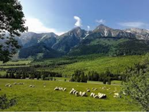
The Low Tatras or Low Tatra is a mountain range of the Inner Western Carpathians in central Slovakia.
The second highest mountain range in Slovakia offers an experience that is quite different from what can be found in the High Tatras. The slopes of the Low Tatras are less precipitous and rocky than those of High Tatras which actually makes them more suitable for skiing and hiking, The Low Tatra as are the largest mountain chain in Slovakia and make up its biggest national park. They form the region of Horehronie and Liptov region
It is located south of the Tatras proper, from which it is separated by the valleys of the Váh and Poprad rivers (the Liptov-Spiš abasement). The valley formed by the Hron River is situated south of the Low Tatras range. The ridge runs west-eastwards and is about 80 km long.
The Čertovica pass divides the range into two parts. The highest peaks of the Low Tatras are located in its western part. Ďumbier is the highest mountain at 2,042 m AMSL. Its neighbour Chopok (2,024 m) is accessible by a chairlift, and it is the most visited place in the Low Tatras. Other peaks in the western part include Dereše (2,004 m) and Chabenec (1,955 m). The highest peak in the eastern part is Kráľova hoľa (1,946 m).
The Low Tatras are extremely popular during the winter. The Jasna resort is the largest ski centre in Slovakia.
Several karst areas are situated in limestone and dolomite formations at the southern and northern edges of the main ridge, which is composed of granite and gneiss. Among many discovered caves, Bystrianska Cave (Bystrianska jaskyňa), Cave of Dead Bats (Jaskyňa mŕtvych netopierov), Demänovská jaskyňa Slobody ( the most visisted in Slovakia), Demänová Ice Cave (Demänovská ľadová jaskyňa), and Važecká Cave (Važecká jaskyňa) are open to the public. The biggest canyon is Hučiaky under Salatín in Ludrová valley near Ružomberok (7 caves – not open for public), suitable for canyoning. The highest waterfall is under Brankov near Ružomberok – Podsuchá (55 m high), reachable by green marked footpath from Podsuchá (20 min). The biggest tarn is Vrbické pleso in the Demänovská dolina Valley.
Resource: wiki
We are glad to provide you our services.
 +421 948 365 187
 info@realdealplus.com


